So, how was the 103 acres in Joliet simultaneously for the whole shebang but also not the end of the road? Many of you may be wondering.
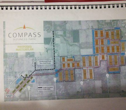
We don’t believe that the 103 acres was ever intended to be built on. It wasn’t part of the original 2200+ acre footprint. As you can see from the original footprint, the 103 acres (in yellow) is farther north and not connected to the original plan (in red). For comparison, you can see the original plan as drawn up by NorthPoint.
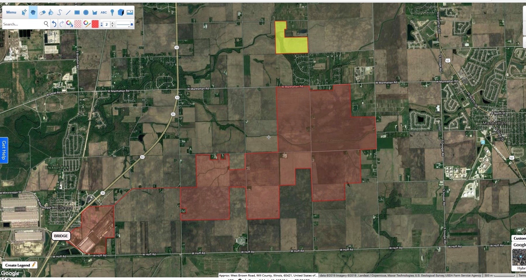

The 103 acres is on an island, essentially, with no water or sewer, land that’s mostly floodplain that includes a creek requiring special use permits, and it is surrounded by roads that have 12 ton weight limits that are governed by Jackson Township. There were other options to the east that were already in the city of Joliet that would’ve been more desirable that were held by the same land broker. In fact, NorthPoint could’ve made a statement if they were really going to go full throttle with Compass Business Park and built on the property that they already own — and that is already zoned industrial — that is already part of the footprint. NorthPoint didn’t own these 103 acres (closing on that property was contingent on NorthPoint being able to secure rezoning per the development agreement). Nothing about that made sense. So why?
The 103 acres was certainly part of the grand scheme of things, but its purpose was not what appears to many at face value. The 103 acres adds tremendously to the fear factor with Manhattan due to its proximity. Yes, it is farther north than the original footprint, but it is also one parcel away from the rest of it. The 103 acres is merely a stepping stone because having this parcel rezoned bought NorthPoint time. Precious investor time. Time to satisfy investors who are weary after continued failures and it bought some time while litigation is ongoing over the bridge over Route 53.
The bridge over Route 53 is the holy grail. Without the bridge, there is no project.
Katie Hunt asked about the bridge during the public hearings in Elwood — when everyone was under oath. You can view her testimony (it’s cued up) here. Or, you can read the testimony here (starting on page 291) Patrick Robinson, visibly frustrated with Katie’s questioning, slumped over in his chair, begrudgingly answered. Now, I know, that guy’s word is trash around here. And I agree, while most of what representatives from NorthPoint say is simply lip service, flat out BS, or what have you, this is a key point.
At the 4:31:00 minute mark (and page 292 in the transcript), Katie asks, “Is the bridge a vital component of this project?” Patrick Robinson responded, “Yes, our application indicates that we would not occupy a building until the bridge is complete.” Katie continued, “OK, so, we could — it’s safe to say if there is no bridge, there would be no Compass Business Park?” Robinson replied, “Uh, there would, uh, this application would cease at that point in time. That’s right. Before the, uh, this body.” Relentless, Katie continued, “So, we could say that really, Elwood is the only community that you can work with to make sure that the bridge is built.” Robinson obliged, “Uh, we’re obviously working very closely with Elwood, IDOT, and a number of interested constituents, but I was asked about my crystal ball, uh, on some of the prior questions, and like, look, y-you, kill this project with us, and I don’t know what happens tomorrow with a different developer.” The dialog continued before Patrick Robinson agreed, flat out, that Katie was “absolutely correct.”
The bridge over route 53 is critical. Bottom line. Without that bridge, Compass Business Park isn’t viable. Here’s why: The bridge would provide the closest, most direct access from Compass Business Park to the intermodal — which means access to the rail yards. Which means $$$.
The logistics industry basically works like this: goods get shipped from China, are moved from seaport by rail to the intermodal, where trucks pick them up and deliver them to warehouses where the goods are sorted and readied for distribution, and then from those warehouses, trucks deliver them to their final destination. That’s what makes CenterPoint an intermodal (intermodal = multiple modes of transportation: shipped – rail – truck). NorthPoint by itself is NOT an intermodal – but it wants to – and needs to – connect to one, which is CenterPoint.
The close proximity to the rail is what makes any warehouse project profitable. The closer to rail means the closer to goods, which means less fuel, less time, and less money (and all of that means more money for developers, tenants and probably investors). NorthPoint needs direct access to the rail to be profitable. Without direct access, the project is too far away to attract tenants (this is also why their property, which was old Centerpoint property, by the way, by Bissell, that they own outright that is already zoned industrial still sits vacant and has since they bought it).
So, that’s why access to the rail (basically Centerpoint intermodal) is important. That’s why BNSF is a huge investor in both NorthPoint and Centerpoint. Why the bridge though? Why can’t they just use roads to access the intermodal?
Well, there used to be a road that did that, Walter Strawn Drive, which runs parallel to the entrance to Abraham Lincoln National Cemetery. That was what used to provide access to the rail and Centerpoint from 53, and that is the road that would provide direct access to CenterPoint from NorthPoint’s footprint.
Except one thing: that road was permanently closed by the Illinois Commerce Commission (ICC for short) in 2017 because semis entering and exiting the port kept hitting the crossing arms that exist at the rail that runs parallel to route 53. The semi-truck traffic also interfered with the funeral processions to Abraham Lincoln National Cemetery. That case to close the crossing and road started in 2013, and it was temporarily shut down in 2015. The stuff never moves quickly, to give you an idea of the process it took to shut it down.
So, that road is no dice. Can’t do it. Won’t work. Not allowed. Donezo. Finito.
What then, did NorthPoint’s come up with for their solution? They’ll build a bridge! Remember, they NEED access to the intermodal. This is not a want — it is a need. $$$$! An August 2015 article from Transport Topics highlights how costs went up after Walter Strawn Drive closed. It’s a big deal.
In order to build a bridge over a highway and the rail, NorthPoint would need approval from the village in which the property exists (Elwood) and the ICC (which governs transportation/logistics/rail issues), as well as IDOT, and I believe the rail line as well. Enter those letters lobbying for support to the governor and state reps (who really have no bearing on the decisions- just political sway).
The bridge that NorthPoint wants to build would be at that same location where Walter Strawn Drive is located (but shut down). The bridge would start at Ira Morgan (which is directly across from Walter Strawn), basically right over by the Bissell warehouse (that is where the old Centerpoint property that NorthPoint bought that would be part of the Compass Business Park footprint). Not only would NorthPoint’s bridge go over Route 53, but also over those problematic RxR tracks and into Centerpoint where the holy rail grail is located— right over what the ICC just closed officially and permanently in 2017.


Anyway, NorthPoint, being the stubborn, undeterred fools that they are, filed a petition with the ICC to get their bridge when everything was going on with Elwood back in February 2018. That case, though seemingly dormant, still exists.
Meanwhile, NorthPoint approached Elwood and essentially said hey, we want this f-ing bridge. Elwood said get F’d. NOPE! NorthPoint said, well hey, we bought the property where the bridge would start on the east end from CBP. And when Elwood sold it to Centerpoint, they had an agreement that Centerpoint could access the intermodal by Walter Strawn drive. We (NP) still think that should happen according to these old ass documents.
Well, Elwood’s lawyer presumably looked them over and said, no. That’s a bunch of bull and we don’t have to give you a bridge. It was a totally different agreement, and you’re wrong (which we have obtained a copy of as well and reviewed and concur with Elwood). Elwood was so confident that they said, we’ll just have a judge tell you the same thing. Enter the chancery case.
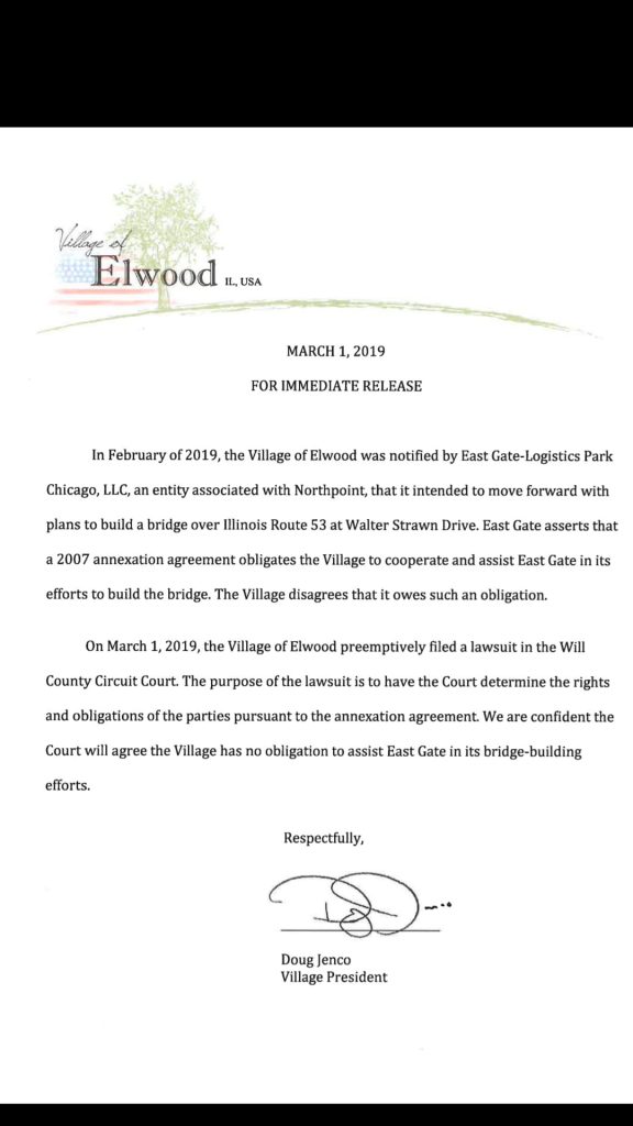
So then NP said, wah wah wah, we will counter sue with specific purpose, which means the only remedy is you giving us this bridge. There were motions to dismiss by both parties. Makes for fun Friday night reading, for sure. It is still in litigation today- not due back in court until January 2020.
But that should give you the idea of the importance of this bridge. Something worth all that trouble isn’t a want. It’s a necessity.
Meanwhile, this 103 acre parcel that just got rezoned doesn’t really, in effect, do anything with regard to Compass Business Park. I hope we aren’t wrong, but that’s our gut reaction after pouring over all of this for days and hours, then dreaming about it, waking up, discussing it some more. Bouncing it off others. Researching. Repeat. We can’t come up with anything else that is a logical conclusion.
What happens next?
Well, there’s a parcel in between that would have to be purchased and annexed — as would all the rest of the Compass Business Park property, plus rezoned from agriculture to industrial. So yes, moooore public hearings, our favorite thing ever, for annexation AND rezoning (which means public notices get sent out, there will be a court recorder, etc. like what we saw in Elwood) before both a plan commission and a village board or city council. Will they be held in Joliet or Manhattan? We don’t know.
But— nothing can happen with Joliet, really, until the Manhattan – Joliet Boundary is up in 2026 due to where this 103 acre property sits in relation to the rest of the footprint and with the boundary line. The only other option would be for NorthPoint to gain a foothold west of that 103 acres and plow through property to the west where they wouldn’t touch that property on Manhattan’s side of the boundary. At the time I published this post, NorthPoint does not own – or at least has not closed on – property farther west that is contiguous that would enable them to do that. Is there land in super secret options? No idea. If there is, those property owners are keeping it very close. Rumors have run rampant, but we can’t substantiate private agreements between a property owner and NorthPoint unless they volunteer that information. We can only deal in the facts that we have before us today. And NorthPoint does not own all of the property that they need. Even if they did, let’s all remember to pour one out for Lakewood Homes, RIP. I think there are still some parcels bearing that long-gone developer’s name. So, NorthPoint is welcome to face a similar fate. Just because they bought it does not mean they get whatever they want.
With Manhattan, well, the village would have to force annex through one of two small parcels with homes to reach the rest of the footprint to annex and rezone (unless one of the larger parcel owners were to oblige, which, good luck with that in either scenario).
When the Manhattan Boundary is up, who knows what will happen. But we have until 2026 to find out, unless someone has a smoking gun they’re hiding, or unless boundary agreements don’t matter.
And at the very least, neither municipality can access property near the proposed the bridge without the Elwood boundary being dead, oh, and with Elwood agreeing to the bridge, which means that court case has to be settled. And then, once the court cases are settled, then they have to resurrect the ICC application and get that approved. Which, given that it took four years to close Walter Strawn Drive, it would seem logical that it would take that long to get approved. If at all. And water and sewer still needs to get piped out there.
Is all this inevitable? Are we fighting a losing battle? Like Patty Cakes Robinson said, I don’t have a crystal ball. I mean, I sure hope not. But I’m sure as hell going to try to stop it. And I hope you continue to fight with me. We have a solid, logical argument why this is a bad deal for the whole area. That’s why our group continues to grow because common sense and reality are quite obvious on this one.
We’ll keep you posted when Patrick Robinson comes out of his crypt to haunt our dreams with the next step in the nightmare. Until then, enjoy the holidays.